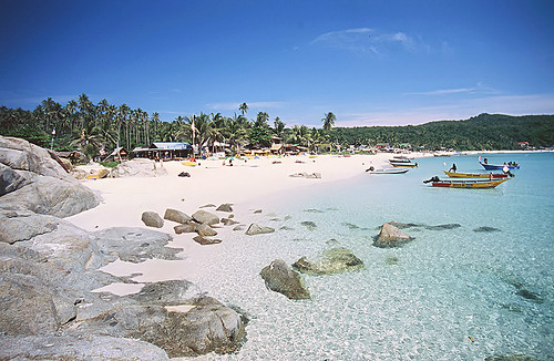
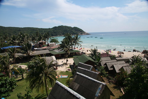
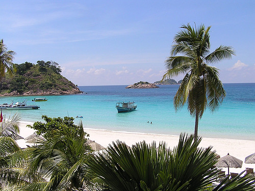
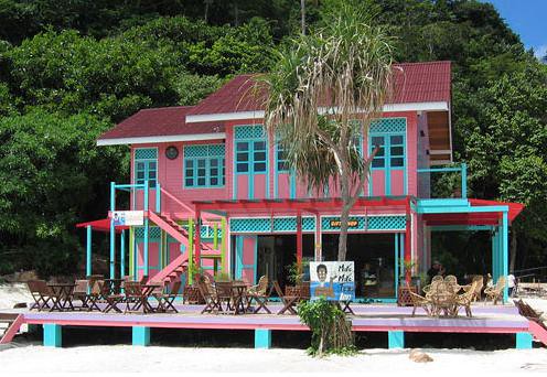
Pangkor Island is an island off the coast of Perak in north-west peninsular Malaysia, reached by ferry from Lumut (a small coastal town that links to Ipoh, or from Sitiawan). It has a land area of only 8 square kilometers, and a population of approximately 25,000 islanders. It is heavily promoted as a low-key tourist destination by the Malaysia government, but fishing and fish products remain major industries.
Historically, Pangkor Island was a refuge for local fishermen, merchants and pirates. In the 17th century, the Dutch built a fort in an effort to control the Perak tin trade. In 1874, it was the location of a historic treaty between a contender to the Perak throne and the British government (The Pangkor Treaty), which began the British colonial domination of the Malay Peninsula.
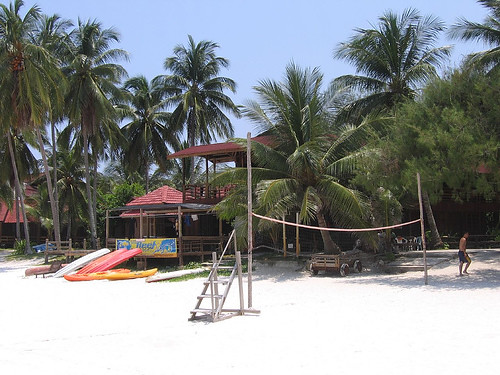
Pangkor Island is famous for its fine beaches and a mix of low budget to 5 star accommodations. Teluk Nipah and Coral Bay on the north west of the Island is extremely popular with backpackers from Europe.
Since the 2004 Indian Ocean tsunami in Indonesia, Thailand and to a lesser extent the West Coast of Malaysia in December 2004, there has been less local tourists visiting Pangkor.
The outstandingly beautiful Emerald Bay lies on the western side of the island. The name is probably derived from its emerald-green water, and combined with the soft, white sand that covers the stretch of beach and the green vegetation that form the backdrop, it's no surprise this beach is regarded the finest beach in Perak.
* Near to Pangkor Island have a small town that name is Pantai Remis. Pantai Remis is about 35km from Lumut jetty to Pangkor Island. Several dishes famous food at Pantai Remis are Laksa, Mee Jawa and Seafood (Especially Seafood in Pantai Remis).
Redang Island Malaysia
Perhentian Island Malaysia
Sipadan Island Malaysia
Langkawi Island Malaysia
Tioman Island Malaysia
Lang Tengah Island Malaysia
TravelYourself
Showing posts with label Island in Malaysia. Show all posts
Showing posts with label Island in Malaysia. Show all posts
Monday, July 23, 2007
Sunday, July 22, 2007
Tioman Island, Malaysia
Tioman Island (locally, Pulau Tioman) is a small island located 32 km off the east coast of Peninsular Malaysia in the state of Pahang, and is some 39 km long and 12 km wide. It has eight main villages, the largest and most populous being Kampung Tekek in the north. Yet, the densely forested island is still sparsely inhabited, and is surrounded by numerous coral reefs, making it a scuba diving haven.
Its beaches were depicted in the 1958 movie, South Pacific as Bali Hai. In the 1970s, TIME magazine selected Tioman as one of the world’s most beautiful islands.
Apart from its diverse marine life, the inland rainforest area, encompassing approximately 12,383 hectares, in Tioman is a strictly enforced reserve. There are several protected species of mammals on the island, including the Binturong, Long-tailed Macaque, Slow Loris, Black Giant Squirrel, Red Giant Flying Squirrel, Mouse deer, Brush-tailed Porcupine, and Common Palm Civet, from a total of 45 species of mammals and 138 species of birds, including the majestic Frigatebird. Moreover, Tioman has species that are endemic to its shores. The soft-shelled turtle and the Tioman walking catfish are both unique and can be seen on rainforest walks.
The island is served by ferries from the Malaysian mainland, and a propeller plane service by Berjaya Air from Singapore (Seletar Airport) and Kuala Lumpur (Kuala Lumpur International Airport)
Tioman has been used for thousands of years by fishermen as an important navigation point and a source of fresh water and wood. During the past thousand years, it has played host to Chinese, Arab, and European trading ships, and often porcelain shards can be found on beaches around the island.
In more recent history, Tioman has played host to both the British and the Japanese during the Second World War, and the waters around the island are littered with war remains (including HMS Repulse and HMS Prince of Wales).
The local resident population is 100% bumiputera (Malay people), all of which are Moslem and Tioman has numerous mosques.
According to legend, Tioman Island is the resting place of a beautiful dragon princess. Whilst flying from China to visit her prince in Singapore, this beautiful maiden stopped to seek solace in the crystal-clear waters of the South China Sea. Enraptured by the charms of the place, she decided to discontinue her journey. By taking the form of an island, she pledged to offer shelter and comfort to passing travelers.
The Malaysian government has big plans for Tioman. In 2004, Kampung Tekek was put up for development as part of a RM40 million (USD$10.9 million) public marina project, despite criticisms from the Malaysian Nature Society, WWF-Malaysia, and the like, who have described the project as a disaster for the environment in Tioman and the surrounding sea. The project covers 127,000 sq metres of the village and includes a yacht marina and also a cargo jetty which will extend 175 meters into the sea.
Villagers, residents and business owners had submitted a petition with 165 signatures to the government to halt this project. Natural Resources and Environment Ministry parliamentary secretary Sazmi Miah accepted the petition on behalf of the government, although the project is still going ahead. Now one year into its construction, the New Sunday Times, a Malaysian national daily, reported on 24 September 2006 that "the surrounding coral reef is breathing its last." The report added:
“ "Experts like coral reef ecologist Affendi Yang Amri estimate that all coral life within a 30-meter radius of the site has been devastated by construction sediment and heavy piling... Prior to the construction, [Affendi and his students] found 220 coral species in waters surrounding the site, 17 of which were considered rare worldwide. These included at least 200 giant clams, classified as "vulnerable" on the Red List of threatened species. "All the clams in this area have died," he says. "They're all being smothered." ”
Affendi is also reported to have said: "Huge table corals, some as wide as an eight-seater dining table, have toppled over from the force of piling. Gorgonian sea fans have disappeared. Fishes have fled, and the seabed is full of dead corals covered with algae." He added that the number of black sea urchins in the area was three times higher than normal, a sign of unhealthy levels of dead corals.
In the same report, Hasnizah Hassan, a chalet manager at the Kampung Tekek beach front said the beach was the most popular beach and tourists could snorkel around the reefs which grew just meters from the beach line where her chalets were located. "The corals are now all choked by sand. You have to swim much further, or take a boat out to see some 'okay-looking' corals... I don't understand it. It's not the duty-free shops that makes tourists come to Tioman. It's the corals. But this is what they are destroying."
A major road linking Kampung Tekek in the west and Kampung Juara in the east is currently under construction and is open to offroad vehicles. The path follows a much earlier road built by the British during the second world war and cuts straight through the jungle. It is slated for completion by 2008.
The various projects that the government is pursuing are having a catastrophic effect on the environment. The marina project has drastically increased sea pollution, and the future enlarged airport will destroy acres of Tioman's best coral reef.
Redang Island Malaysia
Perhentian Island Malaysia
Sipadan Island Malaysia
Langkawi Island Malaysia
Lang Tengah Island, Malaysia
Tioman Island Malaysia
Pangkor Island Malaysia
TravelYourself
Langkawi Island, Malaysia
Langkawi Island is an archipelago of 99 islands in the Andaman Sea, some 30 km off the mainland coast of northwestern Malaysia. The islands are a part of Malaysia's Kedah state, but are adjacent to the Thai border. By far the largest of the islands is the eponymous Pulau Langkawi with a population of some 45,000, the only other inhabited island being nearby Pulau Tuba.
Langkawi lies north of the Straits of Malacca in the southern Andaman Sea near the border between Malaysia and Thailand. Only a few kilometres to the north lies the neighbouring Thai island of Ko Tarutao. The island group's main town, on the main island, is Kuah.
Langkawi's highest point is Gunung Raya, rising to 890 m above sea level in the main island's central-eastern area.
The Isles of Langkawi consists of 104 islands with a total land area of about 528 sq km (204 sq m).
According to a continental drift theory, the huge landmass of Gondwana split into smaller landmasses such as Africa, Australia, India and Langkawi 500 million years ago during the Cambrian Age. Hills in the north-western part of Langkawi Island (including Mt. Machincang) are formed during this continental drift.
The name "Langkawi" is believed to be related to the kingdom of Langkasuka, centred in modern-day Kedah. The historical record is sparse, but a Chinese Liang Dynasty record (c. 500 AD) refers to the kingdom of "Langgasu" as being founded in the 1st century AD. 'Langkawi' means Eagle Island, it may be noted, and indeed there is a great abundance of eagles in the area. In Kuah, the capital, there is a huge eagle monument in Eagle Square which commemorates the origin of Langkawi's name.
Langkawi eventually came under the influence of the Sultanate of Kedah, but Kedah was conquered in 1821 by Siam and Langkawi along with it. The Anglo-Siamese Treaty of 1909 transferred power to the British, who held the state until independence, except for a brief period of Thai rule under the Japanese occupation of Malaya during World War II. Thai influences remain visible in the culture and food of Langkawi, while Thai is still understood by many on the island.
Langkawi Island has recently been re-branded to "LANGKAWI GEOPARK" to better reflect the island's recogition by UNESCO as a World Geopark (on June 1, 2007). Three of its main Geopark components are Mt. Machincang Cambrian Geoforest Park, Kilim Geoforest Park and Pulau Tasik Dayang Bunting (Island of the Pregnant Maiden Lake).
Sheltered by the mountainous backbone of Peninsular Malaysia, Langkawi escapes the northeastern winter monsoon entirely and enjoys sunny skies when the eastern provinces are flooded. Coupled with natural white sand beaches, lush jungle foliage and craggy mountain peaks – but hampered by inaccessibility – the island was at one time touted as "Malaysia's best-kept secret".
Langkawi remained a sleepy backwater until 1987, when the island was granted tax-free status with the intention of promoting tourism. Subsequently the island's airport was upgraded and ferry links were increased.
Today, Langkawi competes with nearby Penang for the title of Malaysia's largest tourist draw. Resorts and 5-star hotels line the beaches and, in the winter high season, direct flights land from as far as Europe and Japan.
Beside the tax-free, beach and eagle, the other attraction in Langkawi are their Cable Car to the tops of Gunung Mat Cincang at 705m above sea level. Galeria Perdana a collection of over 2500 gift to the fourth Prime Minister of Malaysia, Tun Dr. Mahathir Mohamad.
Langkawi is affected by the milder western monsoon (May-September), and while diving is possible at Pulau Payar, water clarity tends to be poor.
From Kuah, there are ferry connections to Satun in southern Thailand, to Penang, to Kuala Kedah and to Kuala Perlis. Langkawi International Airport and the harbour at Telok Ewa lie on the west coast. AirAsia flies to Langkawi from Bangkok and Kuala Lumpur. The whole island has a well developed road network.
For list of Resort and Hotels in Langkawi Island Malaysia, Click here
Redang Island Malaysia
Perhentian Island Malaysia
Sipadan Island Malaysia
Langkawi Island Malaysia
Lang Tengah Island, Malaysia
Tioman Island Malaysia
Pangkor Island Malaysia
TravelYourself
Friday, July 20, 2007
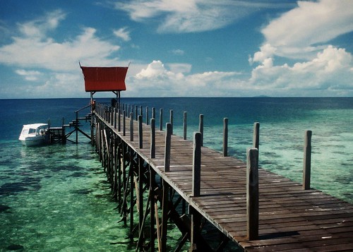
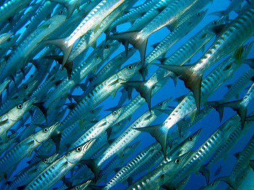
Sipadan Island, Malaysia
Sipadan Island is the only oceanic island in Malaysia, rising 2,000 feet or 600m from the seabed. It is located east of Tawau (Borneo), in the Celebes Sea. It was formed by living corals growing on top of an extinct volcanic cone that took thousands of years to develop. Sipadan is located at the heart of the Indo-Pacific basin, the centre of one of the richest marine habitats in the world. More than 3,000 species of fish and hundreds of coral species have been classified in this ecosystem.
Rare diving scenes such as schools of greenback turtles and hawksbill turtles nesting and mating, schools of barracuda & big-eye trevally in tornado-like formations, pelagic species such as manta rays, eagle rays, scalloped hammerhead sharks and whale sharks can be seen here.
A mysterious turtle tomb lies underneath the column of the island, formed by an underwater limestone cave with a labyrinth of tunnels and chambers that contain many skeletal remains of turtles.
In the past, the island was at the centre of a territorial dispute between Malaysia and Indonesia. The matter was brought for adjudication to the International Court of Justice and, at the end of 2002, the Court awarded the island along with the island of Ligitan to Malaysia, on the basis of the "effective occupation" displayed by the latter's precedessor (Malaysia's former colonial power, Great Britain) and the absence of any other superior title. The Philippines had applied to intervene in the proceedings on the basis of its claim to Northern Borneo, but its request was turned down by the Court early in 2001.
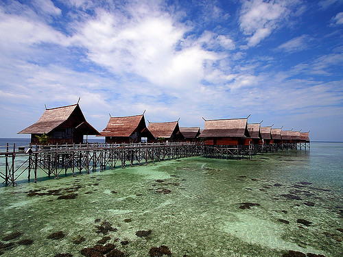
In year 2004, the Government of Malaysia ordered all on-site dive & resort operators of Sipadan to move their structures out of the island by the 31st of December 2004. This move is mainly to conserve a balanced eco-system for Sipadan and its surrounding. Diving will continue to be allowed in Sipadan for divers who are ferried in and out by dive & resort operators from the mainland and surrounding islands.
On May 15, 2006, a barge carrying thousands of tonnes of building material breached on the island, destroying a portion of reef between the old pier and Barracuda Point, said to be about 372sq metres. Thankfully the damage is limited to a small area and is difficult to spot underwater. The purpose of the building supplies (mainly concrete and gravel) was apparently for a USD1.3 million tourist facility including resthouse, toilets and scuba shop, said the State Minister of Tourism, Culture and Environment Tan Sri Chong Kah Kiat but denied by the Chief Minister Datuk Seri Musa Aman. Later, it was reported that it was a Federal Government funded project.
Ever since diving celebrity Jacques Cousteau raved about the diversity of marine life, this dive mecca has been indisputably the most famous scuba destination in Malaysia. It is located off the east coast of Sabah, Malaysia's eastern most state, and lies on the north-eastern corner of Borneo, the world's third largest island.
The Sipadan diving legend has passed through the world's dive community to the extent that all divers with an interest in visiting the best sites in the world, have this small island near the top of their wish list.
Sipadan Island was at the top of Rodale's Scuba Diving Magazine Gold List for (The Top Dive Destination in the World) In fact the island shared its top spot with two other destinations known for the amazing diversity of their marine life - the Galapagos Islands.
he list of attractions is quite staggering and all the more exceptional as it involves big fish encounters, something very rare in Asia these days - at Barracuda Point you can find yourself surrounded by a spiralling vortex of barracuda, so large that the sunlight is often clouded out. At South Point there are scores of reef sharks, large schools of passing trevally and herds of massive marauding bumphead parrotfish. When diving in Sipadan everywhere you turn you'll see turtles, munching on the sponges and algae, or lazing on the wall ledges. If you take the time to look closely at the walls you'll see a wealth of macro life and fish species to rival most destinations, although this is often overlooked due to the other major attractions vying for your attention.
Redang Island Malaysia
Perhentian Island Malaysia
Sipadan Island Malaysia
Langkawi Island Malaysia
Lang Tengah Island, Malaysia
Tioman Island Malaysia
Pangkor Island Malaysia
TravelYourself
Rare diving scenes such as schools of greenback turtles and hawksbill turtles nesting and mating, schools of barracuda & big-eye trevally in tornado-like formations, pelagic species such as manta rays, eagle rays, scalloped hammerhead sharks and whale sharks can be seen here.
A mysterious turtle tomb lies underneath the column of the island, formed by an underwater limestone cave with a labyrinth of tunnels and chambers that contain many skeletal remains of turtles.
In the past, the island was at the centre of a territorial dispute between Malaysia and Indonesia. The matter was brought for adjudication to the International Court of Justice and, at the end of 2002, the Court awarded the island along with the island of Ligitan to Malaysia, on the basis of the "effective occupation" displayed by the latter's precedessor (Malaysia's former colonial power, Great Britain) and the absence of any other superior title. The Philippines had applied to intervene in the proceedings on the basis of its claim to Northern Borneo, but its request was turned down by the Court early in 2001.
In year 2004, the Government of Malaysia ordered all on-site dive & resort operators of Sipadan to move their structures out of the island by the 31st of December 2004. This move is mainly to conserve a balanced eco-system for Sipadan and its surrounding. Diving will continue to be allowed in Sipadan for divers who are ferried in and out by dive & resort operators from the mainland and surrounding islands.
On May 15, 2006, a barge carrying thousands of tonnes of building material breached on the island, destroying a portion of reef between the old pier and Barracuda Point, said to be about 372sq metres. Thankfully the damage is limited to a small area and is difficult to spot underwater. The purpose of the building supplies (mainly concrete and gravel) was apparently for a USD1.3 million tourist facility including resthouse, toilets and scuba shop, said the State Minister of Tourism, Culture and Environment Tan Sri Chong Kah Kiat but denied by the Chief Minister Datuk Seri Musa Aman. Later, it was reported that it was a Federal Government funded project.
Ever since diving celebrity Jacques Cousteau raved about the diversity of marine life, this dive mecca has been indisputably the most famous scuba destination in Malaysia. It is located off the east coast of Sabah, Malaysia's eastern most state, and lies on the north-eastern corner of Borneo, the world's third largest island.
The Sipadan diving legend has passed through the world's dive community to the extent that all divers with an interest in visiting the best sites in the world, have this small island near the top of their wish list.
Sipadan Island was at the top of Rodale's Scuba Diving Magazine Gold List for (The Top Dive Destination in the World) In fact the island shared its top spot with two other destinations known for the amazing diversity of their marine life - the Galapagos Islands.
he list of attractions is quite staggering and all the more exceptional as it involves big fish encounters, something very rare in Asia these days - at Barracuda Point you can find yourself surrounded by a spiralling vortex of barracuda, so large that the sunlight is often clouded out. At South Point there are scores of reef sharks, large schools of passing trevally and herds of massive marauding bumphead parrotfish. When diving in Sipadan everywhere you turn you'll see turtles, munching on the sponges and algae, or lazing on the wall ledges. If you take the time to look closely at the walls you'll see a wealth of macro life and fish species to rival most destinations, although this is often overlooked due to the other major attractions vying for your attention.
Redang Island Malaysia
Perhentian Island Malaysia
Sipadan Island Malaysia
Langkawi Island Malaysia
Lang Tengah Island, Malaysia
Tioman Island Malaysia
Pangkor Island Malaysia
TravelYourself
Wednesday, July 18, 2007
Perhentian Island, Malaysia
The Perhentian Islands (Pulau Perhentian in Malay) lie approximately 10 nautical miles (19 km) offshore the coast of northeastern Malaysia in the state of Terengganu, approximately 40 miles (64 km) south of the Thai border. The two main islands are Perhentian Besar ("Big Perhentian") and Perhentian Kecil ("Small Perhentian"). The small, uninhabited islands of Susu Dara (Virgin Milk), Seringgi and Rawa lie off Kecil. The Perhentians belong to Pulau Redang National Marine Park, which means that fishing, collecting coral and littering are strictly prohibited.
The name "perhentian" means "stopping point" in Malay, referring to their longstanding role as a waypoint for traders between Bangkok and Malaysia. The islands were sparsely inhabited by fishermen for centuries, although tourism now accounts for most economic activity.
The Perhentian Islands appear on many maps of the nineteenth and twentieth century as 'The Station Islands'. This arises from the British colonial period, as an English translation from the Malay "point to stop".
The Perhentian Islands were also used as a refuge in the late 1900s..
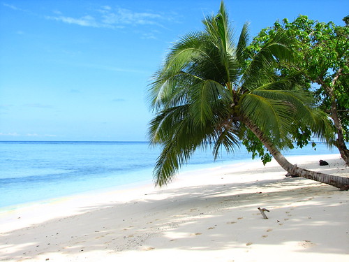
Perhentian Island also has a very beautiful beach call "Pasir Panjang" (Long Beach). It is located at Perhentian Kecil (Small Perhentian). It is a very beautiful white sandy beach, crystal clear water and it is the best place for picnic.
Both islands are fringed by white sand beach, and the reefs and crystalline water are host to a wide variety of coral, sea-turtles, jellyfish, small sharks and reef-fish. The islands' maximum elevation is approximately 100 m and they are uniformly covered in coastal tropical jungle, with few interior foot-trails and no roads.
Other than the owners and staff of the numerous cabin-style resorts that dot the islands (many of whom depart for the monsoon season), the islands' only permanent inhabitants live in a small fishing village on Kecil. With the exception of a single mainland-communications tower, there are no structures taller than two storeys.
In the absence of tourism, economic activity on the Perhentian Islands would be limited to small-scale fishing.
Owing to the Islands' protected status, the main tourist activities are minimal in environmental impact: sunbathing, snorkeling, scuba diving, turtle and shark-watching.
The only electrical power is provided by diesel generators and is not 24-hour. Fresh water is provided by springs. In this respect, the Perhentian Islands are prized by tourists as an 'escape' from the modern world.
As the state of Terengganu follows Islamic customs, the consumption of alcohol and wearing of immodest clothing are discouraged. In order not to offend local inhabitants, tourists are advised to consume alcohol discreetly and to wear one-piece bathing costumes. No penalties are imposed on tourists for 'breaches' of the local customs, however.
The only access to the Islands is by boat from the fishing villages of Kuala Besut and Tok Bali. Local tourist operators run fishing boats and speed boats several times a day.
Redang Island Malaysia
Perhentian Island Malaysia
Sipadan Island Malaysia
Langkawi Island Malaysia
Lang Tengah Island, Malaysia
Tioman Island Malaysia
Pangkor Island Malaysia
TravelYourself
The name "perhentian" means "stopping point" in Malay, referring to their longstanding role as a waypoint for traders between Bangkok and Malaysia. The islands were sparsely inhabited by fishermen for centuries, although tourism now accounts for most economic activity.
The Perhentian Islands appear on many maps of the nineteenth and twentieth century as 'The Station Islands'. This arises from the British colonial period, as an English translation from the Malay "point to stop".
The Perhentian Islands were also used as a refuge in the late 1900s..
Perhentian Island also has a very beautiful beach call "Pasir Panjang" (Long Beach). It is located at Perhentian Kecil (Small Perhentian). It is a very beautiful white sandy beach, crystal clear water and it is the best place for picnic.
Both islands are fringed by white sand beach, and the reefs and crystalline water are host to a wide variety of coral, sea-turtles, jellyfish, small sharks and reef-fish. The islands' maximum elevation is approximately 100 m and they are uniformly covered in coastal tropical jungle, with few interior foot-trails and no roads.
Other than the owners and staff of the numerous cabin-style resorts that dot the islands (many of whom depart for the monsoon season), the islands' only permanent inhabitants live in a small fishing village on Kecil. With the exception of a single mainland-communications tower, there are no structures taller than two storeys.
In the absence of tourism, economic activity on the Perhentian Islands would be limited to small-scale fishing.
Owing to the Islands' protected status, the main tourist activities are minimal in environmental impact: sunbathing, snorkeling, scuba diving, turtle and shark-watching.
The only electrical power is provided by diesel generators and is not 24-hour. Fresh water is provided by springs. In this respect, the Perhentian Islands are prized by tourists as an 'escape' from the modern world.
As the state of Terengganu follows Islamic customs, the consumption of alcohol and wearing of immodest clothing are discouraged. In order not to offend local inhabitants, tourists are advised to consume alcohol discreetly and to wear one-piece bathing costumes. No penalties are imposed on tourists for 'breaches' of the local customs, however.
The only access to the Islands is by boat from the fishing villages of Kuala Besut and Tok Bali. Local tourist operators run fishing boats and speed boats several times a day.
Redang Island Malaysia
Perhentian Island Malaysia
Sipadan Island Malaysia
Langkawi Island Malaysia
Lang Tengah Island, Malaysia
Tioman Island Malaysia
Pangkor Island Malaysia
TravelYourself
Lang Tengah Island, Malaysia
Lang Tengah Island or Pulau Lang Tengah is an island off the coast of Terengganu, Malaysia. It features crystal clear seawater, pristine brilliant white beaches and untouched tropical jungle. It is located roughly halfway between Redang island and Perhentian Island, and is connected to the mainland by ferries to Merang.
The island appeals more to holiday goers who are looking for a quiet tropical island getaway (compared to whats happening in Redang). There are only 3 hotels located on the island including:
Redang Island Malaysia
Perhentian Island Malaysia
Sipadan Island Malaysia
Langkawi Island Malaysia
Tioman Island Malaysia
Pangkor Island Malaysia
TravelYourself
The island appeals more to holiday goers who are looking for a quiet tropical island getaway (compared to whats happening in Redang). There are only 3 hotels located on the island including:
- Square Point Resort
- Redang Lang Resort
- D'Coconut Resort
- Lang Sari Resort
- Blue Coral Island Resort
For list of Resort in Redang Island Malaysia, Click here
Redang Island Malaysia
Perhentian Island Malaysia
Sipadan Island Malaysia
Langkawi Island Malaysia
Tioman Island Malaysia
Pangkor Island Malaysia
TravelYourself
Redang Island, Malaysia
Redang Island, locally known as Pulau Redang or just "Redang" is one of the largest islands off the east coast of Malaysia. It is a popular holiday island for Malaysians, most of whom come on package deals to one of the resorts. Redang is one of nine islands, which form a marine park, and which offer snorkeling and diving opportunities. Access is from Merang or Kuala Terengganu on boats operated by the resorts; there is also a small airport with services operated by Berjaya Air from Singapore (Seletar Airport) and Kuala Lumpur (Sultan Abdul Aziz Shah Airport).
The island is also an important conservation site for sea turtles.
The waters around Pulau Redang also contain two historic shipwrecks. H.M.S Prince of Wales and H.M.S Repulse were sunk here at the start of World War II, setting the stage for the Japanese occupation of Malaya.
The Pulau Redang archipelago comprises Pulau Redang, Pulau Lima, Pulau Paku Besar, Pulau Paku Kecil, Pulau Kerengga Kecil, Pulau Kerengga Besar, Pulau Ekor Tebu, Pulau Ling and Pulau Pinang. Pulau Redang is the biggest of all the islands in the Marine Park, measuring about 7 km long and 6 km wide. It's highest peak is Bukit Besar at 359 metres above sea level. The boundary of the Pulau Redang Marine Park is established by a line linking all points 2 nautical miles from the shores of Pulau Redang, Pulau Lima, Pulau Ekor Tebu and Pulau Pinang.
The other nearby islands of Perhentian Island, Lang Tengah Island, Kapas Island and Susu Dara Island are also gazetted and protected as Marine Parks. Today, only the bigger islands like Redang, Lang Tengah, Perhentian and Kapas have resort facilities for visitors. The management of Marine Parks primarily involves protection of the sensitive marine and terrestrial ecosystems by controlling the impact from human activities. These include waste & pollution management and conservation of coral reefs and terrestrial habitats.
For list of Resort in Redang Island Malaysia, Click here
Weather in Redang Island, Malaysia
Redang Island Malaysia
Perhentian Island Malaysia
Sipadan Island Malaysia
Langkawi Island Malaysia
Lang Tengah Island, Malaysia
Tioman Island Malaysia
Pangkor Island Malaysia
TravelYourself
Subscribe to:
Posts (Atom)