Saturday, November 24, 2007
Saturday, September 8, 2007
Attraction in Putrajaya, Malaysia
Putrajaya is a throughly modem and vibrant city. It is a model township that has been constructed with detailed planning, innovative urban design and utmost concern for the preservation of the environment. Its beautifully landscaped roads and parks as well as modern buildings clearly reflect the duality of its theme- "Garden City, Intelligent City".
The new version to have a new federal Government administrative Centre to replace Kuala Lumpur emerged in the late 1980s. the relocatino was to ensure that Kuala Lumpur will continue to develop as malaysia's principal business and financial centre.
Attraction in Putrajaya:
Taman Wetland
The largest man-made freshwater wetland in the tropics and the first of its kind in Malaysia, Taman Wetland comprises Wetland Park(138 hectares) and the wetland areas (197 hectares).
There are 24 wetland cells in Taman Wetland and the main habitats are mashes,swamp forests and open water areas like ponds and lakes. Several species of local marshland and water birds spotted here include the little egret, little green heron and cinnamon bittern.
Visitors can start by exploring the wetland park, which serves as a gateway to the wetlands area. It houses a Nature Interpretation Centre. An 80 metre high lookout tower, which offer a bird's eye view of putrajaya, two nature trails, wetland plant nursery, a flamingo pond, picnic areas and other public amenities. Visitors can obtain information on the wetland plant bed filtration system, conservation of wetland habitats and uses of wetland products at the park.
Opening Hours
open daily - 9.00am - 7.00 pm
Taman Botani
Taman Botani offers a quiet place for contemplation and introspection. The biggest botanical garden in malaysia, it covers an area of over 92 hactares and contains more trees and plants then commonly seen in other tropical botanical gardens. The park is divided into three sections - flowers, ornamental plants and preservation/research - and houses some 700 species of local plants as well as those from the african and asia-pacific regions.
Taman Botani has been designed as an acradia or a national sanctuary housing a collection of malaysian plant as well as centre for education and research. Tourists can visits the visitor interpretative centre, the explore's trail, palm hill, sun and floral gardens as well as gift shop that offers green-themed memotabilia.
Opening hours
Open daily - 7.00am - 7.00pm (Including Public Holidays)
The new version to have a new federal Government administrative Centre to replace Kuala Lumpur emerged in the late 1980s. the relocatino was to ensure that Kuala Lumpur will continue to develop as malaysia's principal business and financial centre.
Attraction in Putrajaya:
- Taman Wetland
- Taman Botani
- Taman Warisan Pertanian
- Putrajaya Convention Centre
Taman Wetland
The largest man-made freshwater wetland in the tropics and the first of its kind in Malaysia, Taman Wetland comprises Wetland Park(138 hectares) and the wetland areas (197 hectares).
There are 24 wetland cells in Taman Wetland and the main habitats are mashes,swamp forests and open water areas like ponds and lakes. Several species of local marshland and water birds spotted here include the little egret, little green heron and cinnamon bittern.
Visitors can start by exploring the wetland park, which serves as a gateway to the wetlands area. It houses a Nature Interpretation Centre. An 80 metre high lookout tower, which offer a bird's eye view of putrajaya, two nature trails, wetland plant nursery, a flamingo pond, picnic areas and other public amenities. Visitors can obtain information on the wetland plant bed filtration system, conservation of wetland habitats and uses of wetland products at the park.
Opening Hours
open daily - 9.00am - 7.00 pm
Taman Botani
Taman Botani offers a quiet place for contemplation and introspection. The biggest botanical garden in malaysia, it covers an area of over 92 hactares and contains more trees and plants then commonly seen in other tropical botanical gardens. The park is divided into three sections - flowers, ornamental plants and preservation/research - and houses some 700 species of local plants as well as those from the african and asia-pacific regions.
Taman Botani has been designed as an acradia or a national sanctuary housing a collection of malaysian plant as well as centre for education and research. Tourists can visits the visitor interpretative centre, the explore's trail, palm hill, sun and floral gardens as well as gift shop that offers green-themed memotabilia.
Opening hours
Open daily - 7.00am - 7.00pm (Including Public Holidays)
Tuesday, July 31, 2007
Bali Island, Indonesian
Bali is an Indonesian island located the westernmost of the Lesser Sunda Islands, lying between Java to the west and Lombok to the east. It is one of the country's 33 provinces with the provincial capital at Denpasar towards the south of the island. The island is home to the vast majority of Indonesia's small Hindu minority. It is also the largest tourist destination in the country and is renowned for its highly developed arts, including dance, sculpture, painting, leather, metalworking and music.
Bali has been inhabited since early prehistoric times firstly by descendants of a prehistoric race who migrated through mainland Asia to the Indonesian archipelago, thought to have first settled in Bali around 3000 BC.[citation needed] Stone tools dating from this time have been found near the village of Cekik in the island's west.
Balinese culture was strongly influenced by Indian, and particularly Sanskrit, culture, in a process beginning around the 1st century AD. The name Balidwipa has been discovered from various inscriptions, including the Blanjong charter issued by Sri Kesari Warmadewa in 913 AD and mentioning Walidwipa. It was during this time that the complex irrigation system subak was developed to grow rice. Some religious and cultural traditions still in existence today can be traced back to this period. The Hindu Majapahit Empire (1293–1520 AD) on eastern Java founded a Balinese colony in 1343. When the empire declined, there was an exodus of intellectuals, artists, priests and musicians from Java to Bali in the 15th century.
The First European contact with Bali is thought to have been when Dutch explorer Cornelis de Houtman arrived in 1597, though a Portuguese ship had foundered off the Bukit Peninsula as early as 1585.[citation needed] Dutch rule over Bali came later, was more aggressively fought for, and they were never ultimately able to establish themselves as they had in other parts of Indonesia such as Java and Maluku.
In the 1840s, a presence in Bali was established, first in the island's north, by playing various distrustful Balinese realms against each other. The Dutch mounted large naval and ground assaults first against the Sanur region and then Denpasar. The Balinese were hopelessly overwhelmed in number and armament, but rather than face the humiliation of surrender, they mounted a final defensive but suicidal assault, or puputan. Despite Dutch demands for surrender, an estimated 4,000 Balinese marched to their death against the invaders. Afterwards the Dutch governors were able to exercise little influence over the island, and local control over religion and culture generally remained intact.
Japan occupied Bali during World War II during which time a Balinese military officer, Gusti Ngurah Rai, formed a Balinese 'freedom army'. Following Japan's Pacific surrender in August 1945, the Dutch promptly returned to Indonesia, including Bali, immediately to reinstate their pre-war colonial administration. This was resisted by the Balinese rebels now using Japanese weapons.
On 20 November 1946, the Battle of Marga was fought in Tabanan in central Bali. Colonel I Gusti Ngurah Rai, 29 years old, finally rallied his forces in east Bali at Marga Rana, where they made a suicide attack on the heavily armed Dutch. The Balinese battalion was entirely wiped out, breaking the last thread of Balinese military resistance. In 1946 the Dutch constituted Bali as one of the 13 administrative districts of the newly-proclaimed Republic of East Indonesia, a rival state to the Republic of Indonesia which was proclaimed and headed by Sukarno and Hatta. Bali was included in the ‘’Republic of the United States of Indonesia’’ when the Netherlands recognised Indonesian independence on Dec. 29, 1949. In 1950 Bali officially renounced the Dutch union and legally became a province within the Republic of Indonesia.
The 1963 eruption of Mount Agung killed thousands, created economic havoc and forced many displaced Balinese to be transmigrated to other parts of Indonesia.
In 1965, after a failed coup d'etat in Jakarta against the national government of Indonesia, Bali, along with other regions of Indonesia most notably Java, was the scene of widespread killings of (often falsely-accused) members and sympathizers of the Communist Party of Indonesia (PKI) by right-wing General Soeharto-sponsored militias. Possibly more than 100,000 Balinese were killed although the exact numbers are unknown to date and the events remain legally unclosed.[2] Many unmarked but well known mass graves of victims are located around the island[citation needed].
On October 12, 2002, a car bomb attack in the tourist resort of Kuta killed 202 people, largely foreign tourists and injured a further 209. Further bombings occurred three years later in Kuta and nearby Jimbaran Bay.
Bali lies 3.2 km east of Java and approximately 8 degrees south of the equator. East to west, the island is approximately 153 km wide and 112 km north to south (95 by 69 miles, respectively), with a surface area of 5,632 km². The highest point is Mount Agung at 3,142 m (10,308 feet) high, an active volcano that last erupted in March 1963. Mountains cover centre to the eastern side, with Mount Agung the easternmost peak. Mount Batur (1,717 m) is also still active. About 30,000 years ago it experienced a catastrophic eruption — one of the largest known volcanic events on Earth.
In the south the land descends to form an alluvial plain, watered by shallow rivers, drier in the dry season and overflowing during periods of heavy rain.
The principal cities are the northern port of Singaraja, the former colonial capital of Bali, and the present provincial capital and largest city, Denpasar, near the southern coast. The town of Ubud (north of Denpasar), with its art market, museums and galleries, is arguably the cultural center of Bali.
There are major coastal roads and roads that cross the island mainly north-south. Due to the mountainous terrain in the island's center, the roads tend to follow the crests of the ridges across the mountains. There are no railway lines.
The island is surrounded by coral reefs. Beaches in the south tend to have white sand while those in the north and west black sand. The beach town of Padangbai in the south east has both: the main beach and the secret beach have white sand and the south beach and the blue lagoon have much darker sand. Pasut Beach, near Ho River and Pura Segara, is a quiet beach 14 km southwest of Tabanan. The Ho River is navigable by small sampan. Black sand beaches between Pasut and Klatingdukuh are being developed for tourism, but apart from the seaside temple of Tanah Lot, this is not yet a tourist area.
Three decades ago, the Balinese economy was largely agriculture based both in terms of output and employment. Tourism is now the largest single industry and Bali is as a result one of Indonesia’s wealthiest regions. The economy, however, has suffered significantly as a result of the terrorist bombings of 2002 and 2005.
Although in terms of output, tourism is the economy’s largest industry, agriculture is still the island’s biggest employer[citation needed], most notably rice cultivation. Crops grown in smaller amounts include fruit, vegetables and other cash and subsistance crops.[citation needed] A significant number of Balinese are also fishermen. Bali is also famous for its artisans who produce batik and ikat cloth and clothing, wooden carvings, stone carvings and silverware.
Although significant tourism exists in the north, centre and east of the island, the tourist industry is overwhelmingly focused in the south. The main tourist locations are the town of Kuta (with its beach), and its outer suburbs (which were once independent townships) of Legian and Seminyak, Sanur, Jimbaran, Ubud, and the newer development of Nusa Dua. The Ngurah Rai International Airport is located near Jimbaran, on the isthmus joining the southernmost part of the island to the main part of the island. Another increasingly important source of income for Bali is what is called "Congress Tourism" from the frequent international conferences held on the island, especially after the terrorist bombings of 2002; ostensibly to resurrect Bali's damaged tourism industry as well as its tarnished image.
Balinese and Indonesian are the most widely spoken languages in Bali, and like most Indonesians, the vast majority of Balinese people are bilingual or trilingual. There are several indigenous Balinese languages, but most Balinese can also use the most widely spoken option: modern common Balinese. The usage of different Balinese languages was traditionally determined by the Balinese caste system and by clan membership, but this tradition is diminishing.
English is a common third language (and the primary foreign language) of many Balinese, owing to the requirements of the large tourism industry. Japanese is a prominent language on the island, learned by its inhabitants and used on signs.[citation needed] Staff working in Bali's tourist centres are often, by necessity, multilingual to some degree, speaking as many as 8 or 9 different languages to an often surprising level of competence.
Bali is famous for many forms of art, including painting, sculpture, woodcarving, handcrafts, and performing arts. Balinese gamelan music is highly developed and varied. The dances portray stories from Hindu epics such as the Ramayana. Famous Balinese dances include pendet, legong, baris, topeng, barong, and kecak (the monkey dance).
National education programs, mass media and tourism continue to change Balinese culture. Immigration from other parts of Indonesia, especially Java, is changing the ethnic composition of Bali's population.
The Hindu new year, Nyepi, is celebrated in the spring by a day of silence. On this day everyone stays at home and tourists are encouraged to remain in their hotels. On the preceding day large, colorful sculptures of ogoh-ogoh monsters are paraded and finally burned in the evening to drive away evil spirits. Other festivals throughout the year are specified by the Balinese pawukon calendrical system.
Monday, July 23, 2007
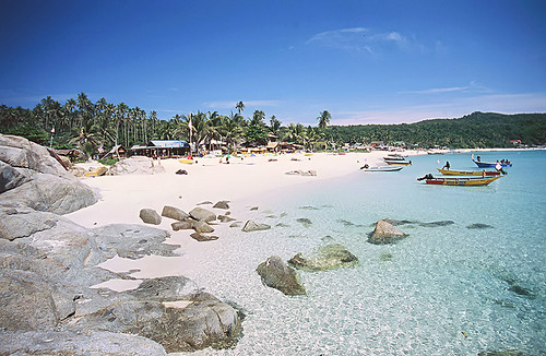
Pangkor Island, Malaysia
Pangkor Island is an island off the coast of Perak in north-west peninsular Malaysia, reached by ferry from Lumut (a small coastal town that links to Ipoh, or from Sitiawan). It has a land area of only 8 square kilometers, and a population of approximately 25,000 islanders. It is heavily promoted as a low-key tourist destination by the Malaysia government, but fishing and fish products remain major industries.
Historically, Pangkor Island was a refuge for local fishermen, merchants and pirates. In the 17th century, the Dutch built a fort in an effort to control the Perak tin trade. In 1874, it was the location of a historic treaty between a contender to the Perak throne and the British government (The Pangkor Treaty), which began the British colonial domination of the Malay Peninsula.
Pangkor Island is famous for its fine beaches and a mix of low budget to 5 star accommodations. Teluk Nipah and Coral Bay on the north west of the Island is extremely popular with backpackers from Europe.
Since the 2004 Indian Ocean tsunami in Indonesia, Thailand and to a lesser extent the West Coast of Malaysia in December 2004, there has been less local tourists visiting Pangkor.
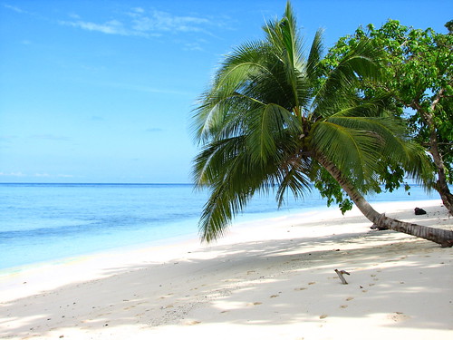
The outstandingly beautiful Emerald Bay lies on the western side of the island. The name is probably derived from its emerald-green water, and combined with the soft, white sand that covers the stretch of beach and the green vegetation that form the backdrop, it's no surprise this beach is regarded the finest beach in Perak.
* Near to Pangkor Island have a small town that name is Pantai Remis. Pantai Remis is about 35km from Lumut jetty to Pangkor Island. Several dishes famous food at Pantai Remis are Laksa, Mee Jawa and Seafood (Especially Seafood in Pantai Remis).
Redang Island Malaysia
Perhentian Island Malaysia
Sipadan Island Malaysia
Langkawi Island Malaysia
Tioman Island Malaysia
Lang Tengah Island Malaysia
TravelYourself
Historically, Pangkor Island was a refuge for local fishermen, merchants and pirates. In the 17th century, the Dutch built a fort in an effort to control the Perak tin trade. In 1874, it was the location of a historic treaty between a contender to the Perak throne and the British government (The Pangkor Treaty), which began the British colonial domination of the Malay Peninsula.
Pangkor Island is famous for its fine beaches and a mix of low budget to 5 star accommodations. Teluk Nipah and Coral Bay on the north west of the Island is extremely popular with backpackers from Europe.
Since the 2004 Indian Ocean tsunami in Indonesia, Thailand and to a lesser extent the West Coast of Malaysia in December 2004, there has been less local tourists visiting Pangkor.
The outstandingly beautiful Emerald Bay lies on the western side of the island. The name is probably derived from its emerald-green water, and combined with the soft, white sand that covers the stretch of beach and the green vegetation that form the backdrop, it's no surprise this beach is regarded the finest beach in Perak.
* Near to Pangkor Island have a small town that name is Pantai Remis. Pantai Remis is about 35km from Lumut jetty to Pangkor Island. Several dishes famous food at Pantai Remis are Laksa, Mee Jawa and Seafood (Especially Seafood in Pantai Remis).
Redang Island Malaysia
Perhentian Island Malaysia
Sipadan Island Malaysia
Langkawi Island Malaysia
Tioman Island Malaysia
Lang Tengah Island Malaysia
TravelYourself
Sunday, July 22, 2007
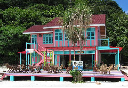
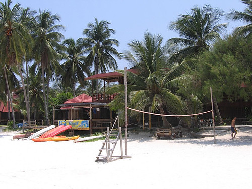
Tioman Island, Malaysia
Tioman Island (locally, Pulau Tioman) is a small island located 32 km off the east coast of Peninsular Malaysia in the state of Pahang, and is some 39 km long and 12 km wide. It has eight main villages, the largest and most populous being Kampung Tekek in the north. Yet, the densely forested island is still sparsely inhabited, and is surrounded by numerous coral reefs, making it a scuba diving haven.
Its beaches were depicted in the 1958 movie, South Pacific as Bali Hai. In the 1970s, TIME magazine selected Tioman as one of the world’s most beautiful islands.
Apart from its diverse marine life, the inland rainforest area, encompassing approximately 12,383 hectares, in Tioman is a strictly enforced reserve. There are several protected species of mammals on the island, including the Binturong, Long-tailed Macaque, Slow Loris, Black Giant Squirrel, Red Giant Flying Squirrel, Mouse deer, Brush-tailed Porcupine, and Common Palm Civet, from a total of 45 species of mammals and 138 species of birds, including the majestic Frigatebird. Moreover, Tioman has species that are endemic to its shores. The soft-shelled turtle and the Tioman walking catfish are both unique and can be seen on rainforest walks.
The island is served by ferries from the Malaysian mainland, and a propeller plane service by Berjaya Air from Singapore (Seletar Airport) and Kuala Lumpur (Kuala Lumpur International Airport)
Tioman has been used for thousands of years by fishermen as an important navigation point and a source of fresh water and wood. During the past thousand years, it has played host to Chinese, Arab, and European trading ships, and often porcelain shards can be found on beaches around the island.
In more recent history, Tioman has played host to both the British and the Japanese during the Second World War, and the waters around the island are littered with war remains (including HMS Repulse and HMS Prince of Wales).
The local resident population is 100% bumiputera (Malay people), all of which are Moslem and Tioman has numerous mosques.
According to legend, Tioman Island is the resting place of a beautiful dragon princess. Whilst flying from China to visit her prince in Singapore, this beautiful maiden stopped to seek solace in the crystal-clear waters of the South China Sea. Enraptured by the charms of the place, she decided to discontinue her journey. By taking the form of an island, she pledged to offer shelter and comfort to passing travelers.
The Malaysian government has big plans for Tioman. In 2004, Kampung Tekek was put up for development as part of a RM40 million (USD$10.9 million) public marina project, despite criticisms from the Malaysian Nature Society, WWF-Malaysia, and the like, who have described the project as a disaster for the environment in Tioman and the surrounding sea. The project covers 127,000 sq metres of the village and includes a yacht marina and also a cargo jetty which will extend 175 meters into the sea.
Villagers, residents and business owners had submitted a petition with 165 signatures to the government to halt this project. Natural Resources and Environment Ministry parliamentary secretary Sazmi Miah accepted the petition on behalf of the government, although the project is still going ahead. Now one year into its construction, the New Sunday Times, a Malaysian national daily, reported on 24 September 2006 that "the surrounding coral reef is breathing its last." The report added:
“ "Experts like coral reef ecologist Affendi Yang Amri estimate that all coral life within a 30-meter radius of the site has been devastated by construction sediment and heavy piling... Prior to the construction, [Affendi and his students] found 220 coral species in waters surrounding the site, 17 of which were considered rare worldwide. These included at least 200 giant clams, classified as "vulnerable" on the Red List of threatened species. "All the clams in this area have died," he says. "They're all being smothered." ”
Affendi is also reported to have said: "Huge table corals, some as wide as an eight-seater dining table, have toppled over from the force of piling. Gorgonian sea fans have disappeared. Fishes have fled, and the seabed is full of dead corals covered with algae." He added that the number of black sea urchins in the area was three times higher than normal, a sign of unhealthy levels of dead corals.
In the same report, Hasnizah Hassan, a chalet manager at the Kampung Tekek beach front said the beach was the most popular beach and tourists could snorkel around the reefs which grew just meters from the beach line where her chalets were located. "The corals are now all choked by sand. You have to swim much further, or take a boat out to see some 'okay-looking' corals... I don't understand it. It's not the duty-free shops that makes tourists come to Tioman. It's the corals. But this is what they are destroying."
A major road linking Kampung Tekek in the west and Kampung Juara in the east is currently under construction and is open to offroad vehicles. The path follows a much earlier road built by the British during the second world war and cuts straight through the jungle. It is slated for completion by 2008.
The various projects that the government is pursuing are having a catastrophic effect on the environment. The marina project has drastically increased sea pollution, and the future enlarged airport will destroy acres of Tioman's best coral reef.
Redang Island Malaysia
Perhentian Island Malaysia
Sipadan Island Malaysia
Langkawi Island Malaysia
Lang Tengah Island, Malaysia
Tioman Island Malaysia
Pangkor Island Malaysia
TravelYourself
Langkawi Island, Malaysia
Langkawi Island is an archipelago of 99 islands in the Andaman Sea, some 30 km off the mainland coast of northwestern Malaysia. The islands are a part of Malaysia's Kedah state, but are adjacent to the Thai border. By far the largest of the islands is the eponymous Pulau Langkawi with a population of some 45,000, the only other inhabited island being nearby Pulau Tuba.
Langkawi lies north of the Straits of Malacca in the southern Andaman Sea near the border between Malaysia and Thailand. Only a few kilometres to the north lies the neighbouring Thai island of Ko Tarutao. The island group's main town, on the main island, is Kuah.
Langkawi's highest point is Gunung Raya, rising to 890 m above sea level in the main island's central-eastern area.
The Isles of Langkawi consists of 104 islands with a total land area of about 528 sq km (204 sq m).
According to a continental drift theory, the huge landmass of Gondwana split into smaller landmasses such as Africa, Australia, India and Langkawi 500 million years ago during the Cambrian Age. Hills in the north-western part of Langkawi Island (including Mt. Machincang) are formed during this continental drift.
The name "Langkawi" is believed to be related to the kingdom of Langkasuka, centred in modern-day Kedah. The historical record is sparse, but a Chinese Liang Dynasty record (c. 500 AD) refers to the kingdom of "Langgasu" as being founded in the 1st century AD. 'Langkawi' means Eagle Island, it may be noted, and indeed there is a great abundance of eagles in the area. In Kuah, the capital, there is a huge eagle monument in Eagle Square which commemorates the origin of Langkawi's name.
Langkawi eventually came under the influence of the Sultanate of Kedah, but Kedah was conquered in 1821 by Siam and Langkawi along with it. The Anglo-Siamese Treaty of 1909 transferred power to the British, who held the state until independence, except for a brief period of Thai rule under the Japanese occupation of Malaya during World War II. Thai influences remain visible in the culture and food of Langkawi, while Thai is still understood by many on the island.
Langkawi Island has recently been re-branded to "LANGKAWI GEOPARK" to better reflect the island's recogition by UNESCO as a World Geopark (on June 1, 2007). Three of its main Geopark components are Mt. Machincang Cambrian Geoforest Park, Kilim Geoforest Park and Pulau Tasik Dayang Bunting (Island of the Pregnant Maiden Lake).
Sheltered by the mountainous backbone of Peninsular Malaysia, Langkawi escapes the northeastern winter monsoon entirely and enjoys sunny skies when the eastern provinces are flooded. Coupled with natural white sand beaches, lush jungle foliage and craggy mountain peaks – but hampered by inaccessibility – the island was at one time touted as "Malaysia's best-kept secret".
Langkawi remained a sleepy backwater until 1987, when the island was granted tax-free status with the intention of promoting tourism. Subsequently the island's airport was upgraded and ferry links were increased.
Today, Langkawi competes with nearby Penang for the title of Malaysia's largest tourist draw. Resorts and 5-star hotels line the beaches and, in the winter high season, direct flights land from as far as Europe and Japan.
Beside the tax-free, beach and eagle, the other attraction in Langkawi are their Cable Car to the tops of Gunung Mat Cincang at 705m above sea level. Galeria Perdana a collection of over 2500 gift to the fourth Prime Minister of Malaysia, Tun Dr. Mahathir Mohamad.
Langkawi is affected by the milder western monsoon (May-September), and while diving is possible at Pulau Payar, water clarity tends to be poor.
From Kuah, there are ferry connections to Satun in southern Thailand, to Penang, to Kuala Kedah and to Kuala Perlis. Langkawi International Airport and the harbour at Telok Ewa lie on the west coast. AirAsia flies to Langkawi from Bangkok and Kuala Lumpur. The whole island has a well developed road network.
For list of Resort and Hotels in Langkawi Island Malaysia, Click here
Redang Island Malaysia
Perhentian Island Malaysia
Sipadan Island Malaysia
Langkawi Island Malaysia
Lang Tengah Island, Malaysia
Tioman Island Malaysia
Pangkor Island Malaysia
TravelYourself
Friday, July 20, 2007
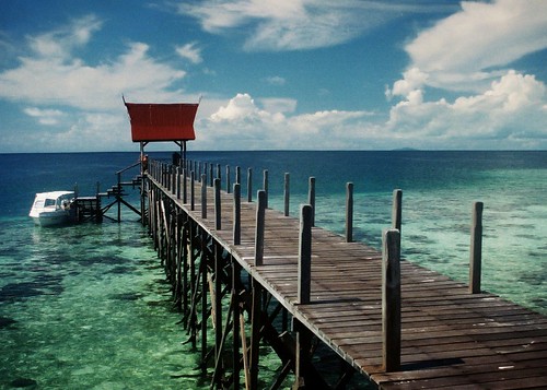
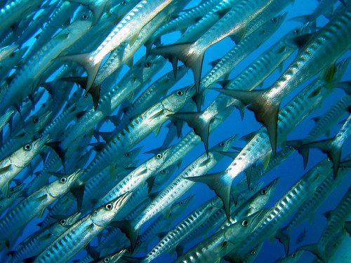
Sipadan Island, Malaysia
Sipadan Island is the only oceanic island in Malaysia, rising 2,000 feet or 600m from the seabed. It is located east of Tawau (Borneo), in the Celebes Sea. It was formed by living corals growing on top of an extinct volcanic cone that took thousands of years to develop. Sipadan is located at the heart of the Indo-Pacific basin, the centre of one of the richest marine habitats in the world. More than 3,000 species of fish and hundreds of coral species have been classified in this ecosystem.
Rare diving scenes such as schools of greenback turtles and hawksbill turtles nesting and mating, schools of barracuda & big-eye trevally in tornado-like formations, pelagic species such as manta rays, eagle rays, scalloped hammerhead sharks and whale sharks can be seen here.
A mysterious turtle tomb lies underneath the column of the island, formed by an underwater limestone cave with a labyrinth of tunnels and chambers that contain many skeletal remains of turtles.
In the past, the island was at the centre of a territorial dispute between Malaysia and Indonesia. The matter was brought for adjudication to the International Court of Justice and, at the end of 2002, the Court awarded the island along with the island of Ligitan to Malaysia, on the basis of the "effective occupation" displayed by the latter's precedessor (Malaysia's former colonial power, Great Britain) and the absence of any other superior title. The Philippines had applied to intervene in the proceedings on the basis of its claim to Northern Borneo, but its request was turned down by the Court early in 2001.
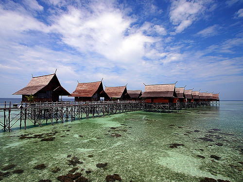
In year 2004, the Government of Malaysia ordered all on-site dive & resort operators of Sipadan to move their structures out of the island by the 31st of December 2004. This move is mainly to conserve a balanced eco-system for Sipadan and its surrounding. Diving will continue to be allowed in Sipadan for divers who are ferried in and out by dive & resort operators from the mainland and surrounding islands.
On May 15, 2006, a barge carrying thousands of tonnes of building material breached on the island, destroying a portion of reef between the old pier and Barracuda Point, said to be about 372sq metres. Thankfully the damage is limited to a small area and is difficult to spot underwater. The purpose of the building supplies (mainly concrete and gravel) was apparently for a USD1.3 million tourist facility including resthouse, toilets and scuba shop, said the State Minister of Tourism, Culture and Environment Tan Sri Chong Kah Kiat but denied by the Chief Minister Datuk Seri Musa Aman. Later, it was reported that it was a Federal Government funded project.
Ever since diving celebrity Jacques Cousteau raved about the diversity of marine life, this dive mecca has been indisputably the most famous scuba destination in Malaysia. It is located off the east coast of Sabah, Malaysia's eastern most state, and lies on the north-eastern corner of Borneo, the world's third largest island.
The Sipadan diving legend has passed through the world's dive community to the extent that all divers with an interest in visiting the best sites in the world, have this small island near the top of their wish list.
Sipadan Island was at the top of Rodale's Scuba Diving Magazine Gold List for (The Top Dive Destination in the World) In fact the island shared its top spot with two other destinations known for the amazing diversity of their marine life - the Galapagos Islands.
he list of attractions is quite staggering and all the more exceptional as it involves big fish encounters, something very rare in Asia these days - at Barracuda Point you can find yourself surrounded by a spiralling vortex of barracuda, so large that the sunlight is often clouded out. At South Point there are scores of reef sharks, large schools of passing trevally and herds of massive marauding bumphead parrotfish. When diving in Sipadan everywhere you turn you'll see turtles, munching on the sponges and algae, or lazing on the wall ledges. If you take the time to look closely at the walls you'll see a wealth of macro life and fish species to rival most destinations, although this is often overlooked due to the other major attractions vying for your attention.
Redang Island Malaysia
Perhentian Island Malaysia
Sipadan Island Malaysia
Langkawi Island Malaysia
Lang Tengah Island, Malaysia
Tioman Island Malaysia
Pangkor Island Malaysia
TravelYourself
Rare diving scenes such as schools of greenback turtles and hawksbill turtles nesting and mating, schools of barracuda & big-eye trevally in tornado-like formations, pelagic species such as manta rays, eagle rays, scalloped hammerhead sharks and whale sharks can be seen here.
A mysterious turtle tomb lies underneath the column of the island, formed by an underwater limestone cave with a labyrinth of tunnels and chambers that contain many skeletal remains of turtles.
In the past, the island was at the centre of a territorial dispute between Malaysia and Indonesia. The matter was brought for adjudication to the International Court of Justice and, at the end of 2002, the Court awarded the island along with the island of Ligitan to Malaysia, on the basis of the "effective occupation" displayed by the latter's precedessor (Malaysia's former colonial power, Great Britain) and the absence of any other superior title. The Philippines had applied to intervene in the proceedings on the basis of its claim to Northern Borneo, but its request was turned down by the Court early in 2001.
In year 2004, the Government of Malaysia ordered all on-site dive & resort operators of Sipadan to move their structures out of the island by the 31st of December 2004. This move is mainly to conserve a balanced eco-system for Sipadan and its surrounding. Diving will continue to be allowed in Sipadan for divers who are ferried in and out by dive & resort operators from the mainland and surrounding islands.
On May 15, 2006, a barge carrying thousands of tonnes of building material breached on the island, destroying a portion of reef between the old pier and Barracuda Point, said to be about 372sq metres. Thankfully the damage is limited to a small area and is difficult to spot underwater. The purpose of the building supplies (mainly concrete and gravel) was apparently for a USD1.3 million tourist facility including resthouse, toilets and scuba shop, said the State Minister of Tourism, Culture and Environment Tan Sri Chong Kah Kiat but denied by the Chief Minister Datuk Seri Musa Aman. Later, it was reported that it was a Federal Government funded project.
Ever since diving celebrity Jacques Cousteau raved about the diversity of marine life, this dive mecca has been indisputably the most famous scuba destination in Malaysia. It is located off the east coast of Sabah, Malaysia's eastern most state, and lies on the north-eastern corner of Borneo, the world's third largest island.
The Sipadan diving legend has passed through the world's dive community to the extent that all divers with an interest in visiting the best sites in the world, have this small island near the top of their wish list.
Sipadan Island was at the top of Rodale's Scuba Diving Magazine Gold List for (The Top Dive Destination in the World) In fact the island shared its top spot with two other destinations known for the amazing diversity of their marine life - the Galapagos Islands.
he list of attractions is quite staggering and all the more exceptional as it involves big fish encounters, something very rare in Asia these days - at Barracuda Point you can find yourself surrounded by a spiralling vortex of barracuda, so large that the sunlight is often clouded out. At South Point there are scores of reef sharks, large schools of passing trevally and herds of massive marauding bumphead parrotfish. When diving in Sipadan everywhere you turn you'll see turtles, munching on the sponges and algae, or lazing on the wall ledges. If you take the time to look closely at the walls you'll see a wealth of macro life and fish species to rival most destinations, although this is often overlooked due to the other major attractions vying for your attention.
Redang Island Malaysia
Perhentian Island Malaysia
Sipadan Island Malaysia
Langkawi Island Malaysia
Lang Tengah Island, Malaysia
Tioman Island Malaysia
Pangkor Island Malaysia
TravelYourself
Thursday, July 19, 2007
Resort in Lang Tengah Island, Malaysia
A comprehensive range of resorts awaits your selection, offering an exciting range of activities, services and amenities for your both business and leisure pursuits. So relax and be on your way to an unforgettable dream holiday in your selected resort!
Below is a list of Resort in Lang Tengah Island, Malaysia:
Blue Coral Island Resort
D'Coconut Lagoon
Redang Lang Resort
Lang Sari Resort

TravelYourself
Below is a list of Resort in Lang Tengah Island, Malaysia:
Blue Coral Island Resort
D'Coconut Lagoon
Redang Lang Resort
Lang Sari Resort
Lang Sari Resort
TravelYourself
Resort in Redang Island, Malaysia
Redang Island Malaysia
A comprehensive range of resorts awaits your selection, offering an exciting range of activities, services and amenities for your both business and leisure pursuits. So relax and be on your way to an unforgettable dream holiday in your selected resort!
Below is a list of Resort in Redang Island, Malaysia:
Redang Bahtera Resort
Redang Bay Resort
Redang Camping Adventure
Redang Holiday Beach Villa
Redang Kalong Resort
Redang Pelangi Resort
Redang Mutiara Beach Resort
Redang Reef Resort
Ayu Mayang Resort
Berjaya Redang Beach Resort
Berjaya Redang Spa Resort
Coral Redang Island Resort
Laguna Redang Island Resort
TravelYourself
Wednesday, July 18, 2007
Perhentian Island, Malaysia
The Perhentian Islands (Pulau Perhentian in Malay) lie approximately 10 nautical miles (19 km) offshore the coast of northeastern Malaysia in the state of Terengganu, approximately 40 miles (64 km) south of the Thai border. The two main islands are Perhentian Besar ("Big Perhentian") and Perhentian Kecil ("Small Perhentian"). The small, uninhabited islands of Susu Dara (Virgin Milk), Seringgi and Rawa lie off Kecil. The Perhentians belong to Pulau Redang National Marine Park, which means that fishing, collecting coral and littering are strictly prohibited.
The name "perhentian" means "stopping point" in Malay, referring to their longstanding role as a waypoint for traders between Bangkok and Malaysia. The islands were sparsely inhabited by fishermen for centuries, although tourism now accounts for most economic activity.
The Perhentian Islands appear on many maps of the nineteenth and twentieth century as 'The Station Islands'. This arises from the British colonial period, as an English translation from the Malay "point to stop".
The Perhentian Islands were also used as a refuge in the late 1900s..
Perhentian Island also has a very beautiful beach call "Pasir Panjang" (Long Beach). It is located at Perhentian Kecil (Small Perhentian). It is a very beautiful white sandy beach, crystal clear water and it is the best place for picnic.
Both islands are fringed by white sand beach, and the reefs and crystalline water are host to a wide variety of coral, sea-turtles, jellyfish, small sharks and reef-fish. The islands' maximum elevation is approximately 100 m and they are uniformly covered in coastal tropical jungle, with few interior foot-trails and no roads.
Other than the owners and staff of the numerous cabin-style resorts that dot the islands (many of whom depart for the monsoon season), the islands' only permanent inhabitants live in a small fishing village on Kecil. With the exception of a single mainland-communications tower, there are no structures taller than two storeys.
In the absence of tourism, economic activity on the Perhentian Islands would be limited to small-scale fishing.
Owing to the Islands' protected status, the main tourist activities are minimal in environmental impact: sunbathing, snorkeling, scuba diving, turtle and shark-watching.
The only electrical power is provided by diesel generators and is not 24-hour. Fresh water is provided by springs. In this respect, the Perhentian Islands are prized by tourists as an 'escape' from the modern world.
As the state of Terengganu follows Islamic customs, the consumption of alcohol and wearing of immodest clothing are discouraged. In order not to offend local inhabitants, tourists are advised to consume alcohol discreetly and to wear one-piece bathing costumes. No penalties are imposed on tourists for 'breaches' of the local customs, however.
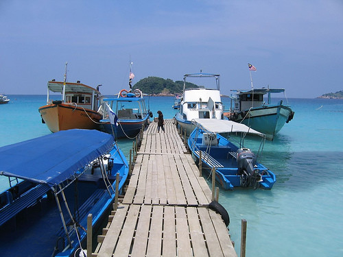
The only access to the Islands is by boat from the fishing villages of Kuala Besut and Tok Bali. Local tourist operators run fishing boats and speed boats several times a day.
Redang Island Malaysia
Perhentian Island Malaysia
Sipadan Island Malaysia
Langkawi Island Malaysia
Lang Tengah Island, Malaysia
Tioman Island Malaysia
Pangkor Island Malaysia
TravelYourself
The name "perhentian" means "stopping point" in Malay, referring to their longstanding role as a waypoint for traders between Bangkok and Malaysia. The islands were sparsely inhabited by fishermen for centuries, although tourism now accounts for most economic activity.
The Perhentian Islands appear on many maps of the nineteenth and twentieth century as 'The Station Islands'. This arises from the British colonial period, as an English translation from the Malay "point to stop".
The Perhentian Islands were also used as a refuge in the late 1900s..
Perhentian Island also has a very beautiful beach call "Pasir Panjang" (Long Beach). It is located at Perhentian Kecil (Small Perhentian). It is a very beautiful white sandy beach, crystal clear water and it is the best place for picnic.
Both islands are fringed by white sand beach, and the reefs and crystalline water are host to a wide variety of coral, sea-turtles, jellyfish, small sharks and reef-fish. The islands' maximum elevation is approximately 100 m and they are uniformly covered in coastal tropical jungle, with few interior foot-trails and no roads.
Other than the owners and staff of the numerous cabin-style resorts that dot the islands (many of whom depart for the monsoon season), the islands' only permanent inhabitants live in a small fishing village on Kecil. With the exception of a single mainland-communications tower, there are no structures taller than two storeys.
In the absence of tourism, economic activity on the Perhentian Islands would be limited to small-scale fishing.
Owing to the Islands' protected status, the main tourist activities are minimal in environmental impact: sunbathing, snorkeling, scuba diving, turtle and shark-watching.
The only electrical power is provided by diesel generators and is not 24-hour. Fresh water is provided by springs. In this respect, the Perhentian Islands are prized by tourists as an 'escape' from the modern world.
As the state of Terengganu follows Islamic customs, the consumption of alcohol and wearing of immodest clothing are discouraged. In order not to offend local inhabitants, tourists are advised to consume alcohol discreetly and to wear one-piece bathing costumes. No penalties are imposed on tourists for 'breaches' of the local customs, however.
The only access to the Islands is by boat from the fishing villages of Kuala Besut and Tok Bali. Local tourist operators run fishing boats and speed boats several times a day.
Redang Island Malaysia
Perhentian Island Malaysia
Sipadan Island Malaysia
Langkawi Island Malaysia
Lang Tengah Island, Malaysia
Tioman Island Malaysia
Pangkor Island Malaysia
TravelYourself
Lang Tengah Island, Malaysia
Lang Tengah Island or Pulau Lang Tengah is an island off the coast of Terengganu, Malaysia. It features crystal clear seawater, pristine brilliant white beaches and untouched tropical jungle. It is located roughly halfway between Redang island and Perhentian Island, and is connected to the mainland by ferries to Merang.
The island appeals more to holiday goers who are looking for a quiet tropical island getaway (compared to whats happening in Redang). There are only 3 hotels located on the island including:
Redang Island Malaysia
Perhentian Island Malaysia
Sipadan Island Malaysia
Langkawi Island Malaysia
Tioman Island Malaysia
Pangkor Island Malaysia
TravelYourself
The island appeals more to holiday goers who are looking for a quiet tropical island getaway (compared to whats happening in Redang). There are only 3 hotels located on the island including:
- Square Point Resort
- Redang Lang Resort
- D'Coconut Resort
- Lang Sari Resort
- Blue Coral Island Resort
For list of Resort in Redang Island Malaysia, Click here
Redang Island Malaysia
Perhentian Island Malaysia
Sipadan Island Malaysia
Langkawi Island Malaysia
Tioman Island Malaysia
Pangkor Island Malaysia
TravelYourself
Redang Island, Malaysia
Redang Island, locally known as Pulau Redang or just "Redang" is one of the largest islands off the east coast of Malaysia. It is a popular holiday island for Malaysians, most of whom come on package deals to one of the resorts. Redang is one of nine islands, which form a marine park, and which offer snorkeling and diving opportunities. Access is from Merang or Kuala Terengganu on boats operated by the resorts; there is also a small airport with services operated by Berjaya Air from Singapore (Seletar Airport) and Kuala Lumpur (Sultan Abdul Aziz Shah Airport).
The island is also an important conservation site for sea turtles.
The waters around Pulau Redang also contain two historic shipwrecks. H.M.S Prince of Wales and H.M.S Repulse were sunk here at the start of World War II, setting the stage for the Japanese occupation of Malaya.
The Pulau Redang archipelago comprises Pulau Redang, Pulau Lima, Pulau Paku Besar, Pulau Paku Kecil, Pulau Kerengga Kecil, Pulau Kerengga Besar, Pulau Ekor Tebu, Pulau Ling and Pulau Pinang. Pulau Redang is the biggest of all the islands in the Marine Park, measuring about 7 km long and 6 km wide. It's highest peak is Bukit Besar at 359 metres above sea level. The boundary of the Pulau Redang Marine Park is established by a line linking all points 2 nautical miles from the shores of Pulau Redang, Pulau Lima, Pulau Ekor Tebu and Pulau Pinang.
The other nearby islands of Perhentian Island, Lang Tengah Island, Kapas Island and Susu Dara Island are also gazetted and protected as Marine Parks. Today, only the bigger islands like Redang, Lang Tengah, Perhentian and Kapas have resort facilities for visitors. The management of Marine Parks primarily involves protection of the sensitive marine and terrestrial ecosystems by controlling the impact from human activities. These include waste & pollution management and conservation of coral reefs and terrestrial habitats.
For list of Resort in Redang Island Malaysia, Click here
Weather in Redang Island, Malaysia
Redang Island Malaysia
Perhentian Island Malaysia
Sipadan Island Malaysia
Langkawi Island Malaysia
Lang Tengah Island, Malaysia
Tioman Island Malaysia
Pangkor Island Malaysia
TravelYourself
Thursday, July 12, 2007
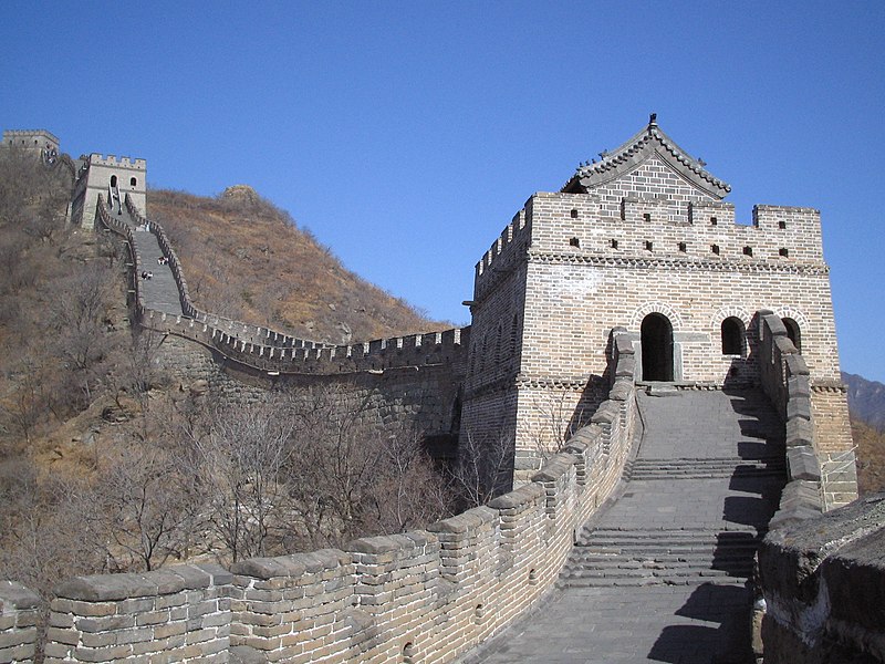
Great Wall of China
The Great Wall (Simplified Chinese: 万里长城) is a series of stone and earthen fortifications in China, built, rebuilt, and maintained between the 5th century BC and the 16th century to protect the northern borders of the Chinese Empire during the rule of successive dynasties. Several walls, referred to as the Great Wall of China, were built since the 5th century BC, the most famous being the one built between 220 BC and 200 BC by the first Emperor of China, Qin Shi Huang. That wall was much farther north than the current wall, built during the Ming Dynasty, and little of it remains.
The Great Wall is the world's longest human-made structure, stretching over approximately 6,400 km (4,000 miles) from Shanhai Pass in the east to Lop Nur in the west, along an arc that roughly delineates the southern edge of Inner Mongolia. It is also the largest human-made structure ever built in terms of surface area and mass.
While some portions north of Beijing and near tourist centers have been preserved and even reconstructed, in many locations the Wall is in disrepair. Those parts might serve as a village playground or a source of stones to rebuild houses and roads. Sections of the Wall are also prone to graffiti and vandalism. Parts have been destroyed because the Wall is in the way of construction. No comprehensive survey of the wall has been carried out, so it is not possible to say how much of it survives, especially in remote areas. Intact or repaired portions of the Wall near developed tourist areas are often frequented by sellers of tourist kitsch.
The wall also has watch towers at regular intervals, which were used to store weapons, house troops, and send smoke signals. Barracks and administrative centers are located at larger intervals.
Communication between the army units along the length of the Great Wall, including the ability to call reinforcements and warn garrisons of enemy movements, was of high importance. Signal towers were built upon hill tops or other high points along the wall for their visibility.
The Great Wall is visibility from the moon.


TravelYourself
The Great Wall is the world's longest human-made structure, stretching over approximately 6,400 km (4,000 miles) from Shanhai Pass in the east to Lop Nur in the west, along an arc that roughly delineates the southern edge of Inner Mongolia. It is also the largest human-made structure ever built in terms of surface area and mass.
While some portions north of Beijing and near tourist centers have been preserved and even reconstructed, in many locations the Wall is in disrepair. Those parts might serve as a village playground or a source of stones to rebuild houses and roads. Sections of the Wall are also prone to graffiti and vandalism. Parts have been destroyed because the Wall is in the way of construction. No comprehensive survey of the wall has been carried out, so it is not possible to say how much of it survives, especially in remote areas. Intact or repaired portions of the Wall near developed tourist areas are often frequented by sellers of tourist kitsch.
The wall also has watch towers at regular intervals, which were used to store weapons, house troops, and send smoke signals. Barracks and administrative centers are located at larger intervals.
Communication between the army units along the length of the Great Wall, including the ability to call reinforcements and warn garrisons of enemy movements, was of high importance. Signal towers were built upon hill tops or other high points along the wall for their visibility.
The Great Wall is visibility from the moon.
TravelYourself
Forbidden City Beijing China
The Forbidden City was the Chinese imperial palace from the mid-Ming Dynasty to the end of the Qing Dynasty. It is located in the middle of Beijing, China. It now houses the Palace Museum.
Built from 1406 to 1420, the complex consists of 980 surviving buildings with 8,707 bays of rooms and covers 720,000 square metres. The palace complex exemplifies traditional Chinese palatial architecture, and has influenced cultural and architectural developments in East Asia and elsewhere. The Forbidden City was declared a World Heritage Site in 1987, and is listed by UNESCO as the largest collection of preserved ancient wooden structures in the world.
Since 1924, the Forbidden City has been under the charge of the Palace Museum, whose extensive collection of artwork and artefacts were built upon the imperial collections of the Ming and Qing dynasties. Part of the museum's former collection is now located in the National Palace Museum in Taipei. Both museums descend from the same institution, but were split after the Chinese Civil War.
Since 1924, the Forbidden City has been under the charge of the Palace Museum, whose extensive collection of artwork and artefacts were built upon the imperial collections of the Ming and Qing dynasties. Part of the museum's former collection is now located in the National Palace Museum in Taipei. Both museums descend from the same institution, but were split after the Chinese Civil War.
Currently, the Palace Museum is responsible for the preservation and restoration of the Forbidden City. Building heights around the Forbidden City are restricted. In 2005, a sixteen-year restoration project was started to repair and restore all buildings in the Forbidden City to their pre-1912 state. This is the largest restoration of the Forbidden City undertaken in two centuries, and involves progressively closing off sections of the Forbidden City for assessment, repairs, and restoration. As part of the project, some derelict or destroyed sections such as the gardens of the Palace of Establishing Prosperity will be re-built.
While great effort has been made to prevent the commercialisation of the palace, a variety of commercial enterprises exist, such as souvenir shops and photography stands. These commercial enterprises often rouse controversy. A new Starbucks store has sparked objections, while souvenir shops that refuse to serve Chinese citizens have received media attention.
Wednesday, July 4, 2007
Resort or Hotel in Bali, Indonesia
List of Hotels and Resorts in Bali, Indonesia and including all the Bali Hotels and Resort Official Web Site Links.
Ramada Resort Benoa Bali
Conrad Bali Resort & Spa
Club Bali Mirage All Inclusive
The Ritz-Carlton, Bali Resort & Spa
Melia Bali Villas & Spa
Kupu Kupu Barong Resort
The Laguna Resort & Spa - Nusa Dua
Pat-Mase Villas
Villa Puri Ayu
Le Meridien Nirwana Golf & Spa Resort
The Vira Bali Hotel
Alila Manggis
Green Garden Hotel Bali
karma jimbaran Bali
Hard Rock Hotel Bali
Alam Puri Villa
ASTON BALI RESORT & SPA
ADHI JAYA HOTEL
HOTEL PURI RAJA
HOTEL SANUR INDAH
HOTEL WINA
INNA BALI
MASHROOM BEACH BUNGALOWS
MATAHARI TERBIT RESORT
PERTIWI RESORT & SPA
BALI COCONUT HOTEL
TAMAN SAKTI RESORT
THE SEMINYAK SUITE
GUNUNG MERTA BUNGALOWS
Top 10 Islands Year 2006
1. Bali - Hotel/Resolt
2. Kauai
3. Maui
4. Cape Breton Island, Nova Scotia
5. Mount Desert Island, Maine
6. Tasmania
7. Hawaii
8. Galápagos Islands
9. Santorini
10. Phuket, Thailand
2. Kauai
3. Maui
4. Cape Breton Island, Nova Scotia
5. Mount Desert Island, Maine
6. Tasmania
7. Hawaii
8. Galápagos Islands
9. Santorini
10. Phuket, Thailand
Tuesday, June 19, 2007
Best dive destinations in the Caribbean/Atlantic
The top dive destinations in the Caribbean/Atlantic, from Scuba Diving magazine's annual reader survey:
1. Bonaire
2. Dominica
3. Cozumel, Mexico
4. Little Cayman and Cayman Brac, Cayman Islands.
5. British Virgin Islands
6. Grand Cayman, Cayman Islands
7. The Atolls, Belize
8. Grand Turk and Salt Cay, Turks & Caicos
9. Curaçao
10. Roatán, Bay Islands, Honduras
1. Bonaire
2. Dominica
3. Cozumel, Mexico
4. Little Cayman and Cayman Brac, Cayman Islands.
5. British Virgin Islands
6. Grand Cayman, Cayman Islands
7. The Atolls, Belize
8. Grand Turk and Salt Cay, Turks & Caicos
9. Curaçao
10. Roatán, Bay Islands, Honduras
TOP 10 TIPS TO AVOID JET LAG
1 Adjust your bedtime by an hour a day: A few days before your trip, start changing your sleep patterns to match the schedule for your destination.
2 Reset your watch on the plane: This helps you adjust quickly to a new destination.
3 Drink plenty of water before, during and after your flight: The air on planes is extremely dry, and dehydration is believed to be a leading cause of jet lag.
4 Avoid drinking alcohol or caffeine during your flight:Both increase dehydration.
5 Sleep on the plane if it's nighttime at your destination: Use earplugs, headphones, eye masks or other sleep aids. Also use a travel pillow.
6 Stay awake during your flight if it's daytime at your destination: Read, watch a movie or visit with other passengers.
7 Exercise as much as you can on the flight: Stretch your back, arms and leg muscles. Walk up and down aisles. Squeeze a rubber ball to stimulate circulation.
8 Eat lightly but strategically: High-protein meals may keep you awake. Foods high in carbohydrates promote sleep. Fatty foods make you feel sluggish.
9 Try a new product: Some folks say melatonin helps combat jet lag by promoting sleep. Others rely on homeopathic products.
10 Arrive a day early: Your body can adjust to a time change gradually.
Saturday, June 2, 2007
热浪岛
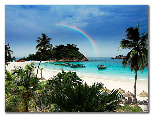
洁白的沙滩,水晶清澈湛蓝的海水,灿烂的海底世界... Redang群岛共有9群岛(利马岛,审问besar岛,审问大臣岛kerenggabesar岛kerengga大臣岛ekortebu岛岭岛,槟榔岛,主要redang岛),盛产神奇的海洋鱼类,海龟和珊瑚礁,确保大snorkelling和潜水.
作为世界上最大的岛屿之间redang列岛pulauredang不仅提出了著名的白色沙滩,但它也是世界上躺不值这个水晶清水中,不仅是天堂,海洋生命,也是自然的爱好者. 浮潜或潜水,在周围的海域pulauredang是一个美丽的地方经验,笔他周围的水pulauredang住有大约3000种鱼类,1.000种贝类500种造礁珊瑚建设.
珊瑚礁被发现在浅水以及水深群岛周围. 它们由逐渐积累和转化小小的软体动物有密切关系,海葵等. 其中一个很常见的珊瑚群,发现在该水域的pulauredang是鹿角珊瑚. 这珊瑚通常出现在浅水区. 它们是绿色,棕色或黄的颜色,他们提供住房的各种小型鱼类和其他海洋动物.
在较深的水有海的歌迷,软珊瑚树,杯珊瑚和若干种裸. 一些深层的岩石都复盖着leathery软珊瑚与软珊瑚树,珊瑚杯,tunicates和海绵. 大砗磲常常在这里找到.
然后于沙本身有较大的软珊瑚和海歌迷,鞭珊瑚,珊瑚表,蘑菇状珊瑚石珊瑚,裸,海星星,cushin恒星和海胆.
也许你会同意的荣耀,这水下花园月食如果没有生存的鱼类. 鱼类互相追逐的珊瑚或游泳团体在深蓝色的大海,像一组巡逻的士兵,以此作为花园的魅力和缤纷的色彩的艺术家.
shoaling鱼类如千斤顶和鲷rabbitfish,或是石斑鱼银barracudas,绽放,triggerfish,鹦,stingrays,hammerheads和绿海龟等总是惊喜的潜水员. 有几次,当潜水员发现鲸鲨在大山一个最受欢迎的潜水地点pulauredang. 而如果你够幸运,你可能会看到一个小鱿鱼,鱿鱼和/或eagleray而浮潜.
最佳位置浮潜这个岛上发现的南部海岸附近pulaupinang和普劳ekortebu. 在海平面以下,你将能看到一些更美丽的海洋生物,包括黄貂鱼,神仙鱼,boxfish和蝴蝶鱼. 还有许多五色鸟吃客海葵,海绵和贝类. 对于潜水爱好者来说,这里笔约有18潜水场周围pulauredang,每个都有自己的方式感到惊讶的潜水员.
保育已发生宪这个岛屿之一的海洋公园,马来西亚为了保护海洋生物,在这个海洋乐园. 活动如捕鱼、采集珊瑚和其他海洋生物,而直接在礁船停靠在两浬禁止这些岛屿.
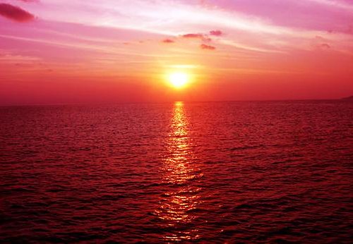
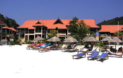
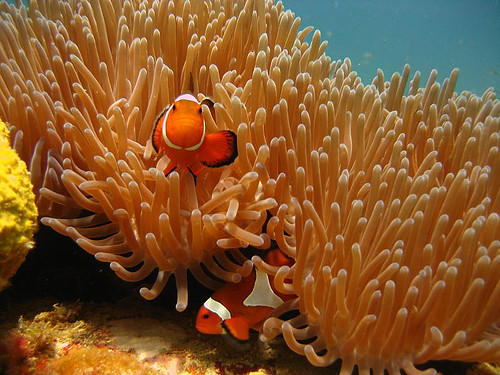
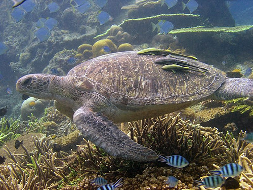
Subscribe to:
Comments (Atom)